Trail Walking Le Valtin - Le gazon du faing - Photo

Le gazon du faing

 pascalou73
pascalou73

User GUIDE

© OpenStreetMap contributors
Length
Length
8.9 km
Max alt
Max alt
1302 m
Uphill gradient
Uphill gradient
263 m
Km-Effort
Km-Effort  
12.4 km
Min alt
Min alt
1217 m
Downhill gradient
Downhill gradient
262 m
Boucle
Boucle
Yes
Creation date :
2015-10-16 00:00:00.0
Updated on :
2015-10-16 00:00:00.0

(0 Reviews)

Walking
Walking
2h45
Difficulty : Medium

Scan this QR Code to open this trail in the SityTrail application

FREE GPS app for hiking

Logo SityTrail SityTrail

IGN / Geographical institutes

Download SityTrail from the App Store Download SityTrail from Google Play

Logo SityTrail SityTrail World

The world is yours!

Download SityTrail from the App Store Download SityTrail from Google Play Download SityTrail on Huawei AppGallery

About

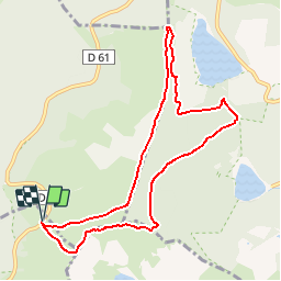
Trail Walking of 8.9 km to be discovered at Grand Est, Vosges, Le Valtin. This trail is proposed by pascalou73.

Description

Très belle rando qui est partagée entre sentiers verdoyants de nombreuses bruyères et des roches on se croirait presque dans les Fagnes Belges mise à part le décor très vallonné des Vosges. Sur le parcours vous pourrez vous arrêtes plusieurs fois pour admirer de beaux points de vues sur la vallée et les lacs Blanc et Noir et lac du Forlet.

Elevation profile

Photos

Points of interest

Point of interest Villarodin-Bourget - 001 - Photo
pascalou73
VILLARODIN-BOURGET 
Point of interest Orbey - 001 1 - Photo
pascalou73
ORBEY 
Point of interest Orbey - 002 - Photo
pascalou73
ORBEY 
Point of interest Bouillon - Aire de pic-nique - Photo
pascalou73
Point of interest Bouillon - Banc - Photo
pascalou73
BOUILLON 
Point of interest Bouillon - Rocher des corbeaux - Photo
pascalou73
Point of interest Orbey - gazon du faing - Photo
pascalou73
Point of interest Plainfaing - gazon du faing - Photo
pascalou73
PLAINFAING 
Point of interest Plainfaing - gazon du faing - Photo
pascalou73
PLAINFAING 

Positioning

Country:
France
Region :
Grand Est
Department/Province :
Vosges
Municipality :
Le Valtin
Location:
Unknown
Start:(UTM)
355934 ; 5330240 (32U) N.

Trails nearby

Trail Horseback riding Orbey - 2020-06-28 WE Orbey Petit Hohnack Glasborn - Photo
Horseback riding
GUIDE
holtzv

Horseback riding

Difficult
(1)
Orbey, Grand Est, Haut-Rhin, France
22 km | 31 km-effort
4h 5min
Yes
Trail Horseback riding Orbey - 2020-06-27 WE Orbey Noir Gazon Vert Forlet - Photo
Horseback riding
GUIDE
holtzv

Horseback riding

Medium
(1)
Orbey, Grand Est, Haut-Rhin, France
21 km | 30 km-effort
3h 59min
Yes
Trail Walking Stosswihr - Tour du belvedere avec le passage sur les crêtes  - Photo
Walking
ocepee

Walking

Very easy
(2)
Stosswihr, Grand Est, Haut-Rhin, France
8.5 km | 0 m-effort
2h 28min
Yes
Trail Other activity Soultzeren - Totom 4 lacs - Photo
Other activity
dinozore

Other activity

Medium
(1)
Soultzeren, Grand Est, Haut-Rhin, France
15.6 km | 26 km-effort
4h 37min
Yes
Trail Walking Hohrod - Circuit historique 1914-18 Hohrodberg - Linge - Photo
Walking
VacheKiri67

Walking

Medium
(1)
Hohrod, Grand Est, Haut-Rhin, France
14 km | 19.8 km-effort
5h 50min
Yes
Trail Walking Orbey - Le Tour du Lac Blanc par le Rocher Hans et le sentier de crête - Photo
Walking
tracegps

Walking

Difficult
(3)
Orbey, Grand Est, Haut-Rhin, France
4.4 km | 7.7 km-effort
2h 30min
Yes
Trail Walking Le Bonhomme - Tête des faux . - Photo
Walking
heurtinpatrick

Walking

Medium
(1)
Le Bonhomme, Grand Est, Haut-Rhin, France
11.9 km | 16.6 km-effort
3h 46min
Yes
Trail Walking Soultzeren - Tanet-Gazon du faing par lac vert et retour sommet du Tanet - Photo
Walking
ride-in-Elsass

Walking

Medium
(1)
Soultzeren, Grand Est, Haut-Rhin, France
10 km | 15.6 km-effort
4h 24min
Yes
Trail Mountain bike Orbey - Lac Blanc  - Têtes des Faux - Photo
Mountain bike
tracegps

Mountain bike

Medium
(1)
Orbey, Grand Est, Haut-Rhin, France
15.3 km | 21 km-effort
1h 0min
Yes


Close
My subscriptions